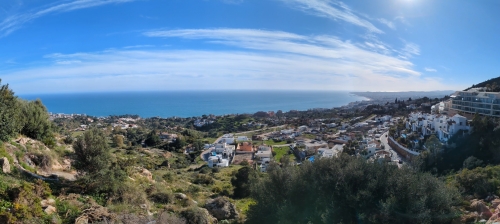
For our second two-week stint in the southern part of the Iberian Peninsula, Mark and I rented a fairly modern apartment in the coastal city of Benalmádena. The main reason for coming to Spain this winter was to check out a few cute Andalusian villages as a potential future base. Ideally, we would have stayed in one of those towns, but higher rents and cooler mountain temperatures in mid-February nudged us towards the Mediterranean coast instead.
View over the town and the Med from Benalmádena
The weather improved for a little while, but our apartment lacked outdoor space to enjoy those elusive sunrays during what turned out to be a particularly cold, windy, and wet winter. The thin walls didn’t help either, especially with loud neighbors above us. We relied on the fan for background noise to sleep.
Andalusia
Around Benalmádena
From Benalmádena to Orgiva
Ronda
The first town we decided to visit was a winner! Mark and I were immediately charmed by the beautiful architecture, narrow cobblestone streets, and spectacular surroundings. We picked a sunny day for our visit and quickly fell in love with Ronda. Yes, it’s touristy—but with good reason.
(As always, click on or hover over photos in galleries to read their captions.)
Fort in Ronda
Nice open space and buildings
First view of the canyon
Narrow streets in Spanish towns are the norm.
View towards the old part of town
The walled city of Ronda
We admired the historic buildings, three different bridges, and the dramatic El Tajo gorge. While we had planned to descend to the river far below, a couple of hours of strolling around town—combined with a fantastic tapas lunch at dog-friendly El Lechuguita—left us without the energy for that steep descent and climb back up.
Interesting church on another pretty square
Wide open promenade along the canyon wall
El Tajo gorge
Outside the famous bullring of Ronda
View into the bullring from a hotel/restaurant balcony
Our popular lunch restaurant
The tapas, atmosphere, and good prices were worth the long wait
Instead, we drove around the outskirts for a better view of what many consider Ronda’s masterpiece: the Puente Nuevo. Completed in 1793, it spans the lush canyon in truly impressive fashion.
The New Bridge from outside of town
The new bridge seen from the bottom of the canyon
Setenil de las Bodegas
Since we still had some daylight left, we made a quick stop in Setenil de las Bodegas—a town I had only recently come across in a blog and that immediately piqued my curiosity.
Beautiful and accurate welcome sign
Having houses built into the rocks is so cool!
A village built in the cliffs
Narrow, steep paths crisscross town
Bell tower with a blue sky
For an hour, we wandered the shaded streets and photographed the homes built directly into the rocks and cliffs. I found this fascinating, as we never saw anything like it before. The closest comparison we could think of were the cave dwellings of Mesa Verde in Colorado—which, of course, are completely different.
Can you believe cars actually drive through these narrow, dripping streets?
A dark alley covered by rock
This remains one of my favorite shots and views of Setenil de las Bodegas
When I realized early last year that I would turn 50 in 2025, I promised myself to do something special for this milestone occasion. But I had no idea what this would be yet. Because of our flexible lifestyle and undetermined schedules, who knew where we would end up in November? It could be Brazil. Or Chile. Or back in Colombia.
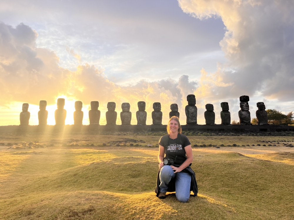
Once we secured buyers for Thirsty Bella, whom we would meet in Santiago de Chile at the beginning of December, my excitement for a destination grew. I’d always wanted to visit Rapa Nui (Easter Island), which belongs to Chile. Mark and I actually had plans for a week-long vacation there in 2014, when we were sailing in French Polynesia. But fate had something much less fun and more impactful in mind twelve years ago. So, we hopped on a plane to the US instead of Rapa Nui to deal with Mark’s health.
Sunrise on Rapa Nui/Easter Island
This magical destination had always been in the back of my mind. Now that I’d be in the capital of Chile, the only place left with regular flights to Hanga Roa, the main town of Easter Island, it was the perfect time to book this trip. Unfortunately, prices for everything—from hostel rooms to flights to the national park fee—had gone up immensely since the pandemic. I sucked it up, yet tried to keep my five-day excursion as cheaply as possible.
(As always, click on or hover over photos in galleries to read their captions.)
Ready for my flight to Rapa Nui!
Our route – Easter Island is not close to anything.
I was the only one on this big, commercial plane wearing a mask
Our plane has landed in Hanga Roa, Easter Island
A welcome sign and local drummers
With only one personal item (Latam Airlines charges extra for carry-on bags as well), I took a cab to the airport early on November 16th and hopped on a plane for five hours. This domestic flight was comfortable and smooth. There was entertainment and—to my surprise—a meal was included. When exiting the plane, passengers were welcomed with Polynesian drumming and dancing. I felt immediately transported back to the South Pacific of our sailing days. It felt great! I had missed the islands and the culture.
To save money, I walked the half hour—a bit overdressed—from the airport to my hostel, enjoyed the views of the ocean and some old and newer statues along the shoreline, and was settled by 2pm, ready for my solo adventure.
Walk along the shoreline to reach my hostel
Another piece of art along my first walk
One of the modern statues along the way
The town’s man-made swimming beach and bay
One of the many statues along the waterfront
The first moai-looking moai I passed by
I have arrived!
This was the moment that I felt I was really and actually on Easter Island
That first afternoon, I had hoped to book a “full” island tour, buy my mandatory national park ticket, inquire about activities, and get my bearings. But because it was Sunday, I couldn’t do much more than explore the town of Hanga Roa and enjoy my first sunset over the moai of Ahu Tahai.
The view from across my hostel
I really liked the grassy areas along the waterfront, made for relaxing.
One of the two protected harbors on the island
Turtle!
Side view of one of the moai along the town’s shore
A different view from the harbor near me and its colorful boats
Sunday at the beach!
I had three full days to take in the sights of Easter Island. My return flight would leave on the afternoon of day five. It seemed like plenty of time.
Almost time for sunset
First sunset on Easter Island
Sunset at Ahu Tahai
On Monday, my plan was to hike along the northern shore and end up at a couple of national park sites to peek at. I had bought my pass for $102 (which had gone up that month from $75 and the bad exchange rate with the US$ made it even more expensive), but most of the sites are only accessible with a guide. Another change since Covid.
Nevertheless, I enjoyed strolling over the bluffs and the volcanic rocks, following horse trails, and spotting the “sunset statues” by day, without the crowds. Statues on the island were erected to honor the (affluent) deceased and later in history, (mass) burials took place underneath the platforms.
Revisiting Ahu Tahai the following morning
View over the platform and a single statue
One of the most-defined statues on this platform
Looking back towards Ahu Tahai and the top hat statue
Restored moai with eyes and a “top hat”
Continuing along the shoreline, I passed another single moai and eventually, I walked through a gate where I was immediately yelled at and kicked out by a ranger. Luckily, a more friendly local gave me a ride back to the village.
Sea crashing over the rocks along the north shore
Walking along the coast towards another moai
I really liked this guy.
My walk along the shoreline revealed another, single moai.
Close-up of this solitary moai
Many rocky bays along the north shore
Leaving the horse trails to follow the main, dirt road for a bit
Naturally carved out rocks
Rubble and ruins along my track
Walking back along the road after being “tossed out.”
In our lifestyle, flexibility is key. I’ve often mentioned that Mark and I both work while traveling the world as nomads—a routine we’ve maintained for over 20 years. Usually, as freelancers, we have a fluid schedule and can adjust our work around the demands and challenges of daily life. But every couple of years, a massive translation project lands in my inbox, forcing us to make solid changes to our plans in exchange for a welcome chunk of income. That’s exactly how we ended up in Rio de Janeiro earlier than planned.
(As always, click on or hover over photos in galleries to read their captions.)
Rio de Janeiro in South America
Rio de Janeiro in Brazil
Rio de Janeiro, the city
When Mark returned from his three-week annual visit to the US at the end of July (while Maya and I held down the fort at a campground), we were eager to meander along Brazil’s famously beautiful coastline, wild camping along the way. That plan lasted two weeks—until the translation assignment arrived. Soon enough, we were parked in the driveway of Fritz House, the property of a Brazilian man of German descent who welcomes overlanders for a fee. His setup included WiFi, water, electricity, toilets, and showers.
Entrance to Fritz House
Not the nicest of campgrounds
The toilet and shower blocks were located down the driveway
This level was the nicest one on the hillside property
View from the “main level” of the campground
The bathroom blocks on the nice and grassy level – only the women’s had a hot shower
Orchid-like flowers on the property
Since I had already started the two-week project en route, we ended up staying 11 nights at Fritz House. I worked full-time while Mark tackled camper projects like repainting our ladder and four electric jacks. We also did laundry that had to line-dry and cleaned the water tanks with bleach.
Mark removes all four jacks
Priming and painting the smaller parts of the ladder
Priming and painting the four electric jacks and the camper ladder
Back to work: spray painting the camper ladder
Freshly painted camper jacks with a new, black touch at the bottom
First Glimpse of Rio
During our stay, we hitched a ride with a tour guide friend for our first look at Rio’s famous beaches. To our pleasant surprise, dogs were welcome. We started at the “fancier” Ipanema Beach, framed by an impressive rock on one side (which technically overlooks Leblon Beach) and a scenic peninsula on the other, where we stumbled upon a professional photo shoot.
Ipanema Beach with the prominent Dois Irmaos rock in the distance
Antarctica is called the Frozen Continent or the White Continent, because it’s covered by a thick layer of ice that measures about 2,000m (6,500ft) and all the snow gives it a white appearance.
It is the coldest, driest, and windiest continent on earth.
Antarctica is the fifth-largest continent on earth at almost twice the size of Australia.
It’s the only continent without year-round inhabitants – While there are research stations on Antarctica, no permanent human population lives there due to the harsh climate and remote location.
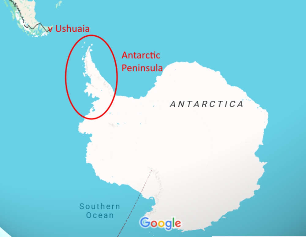
The Antarctic Treaty, signed in 1959 by twelve nations, is a unique and unprecedented agreement to keep peace in Antarctica and act towards its best interests. It applies to the area south of latitude 60°S.
The Antarctic Peninsula makes up a small fraction of the continent, but is the area where tourism is concentrated, due to its unique landscape, abundant marine life, milder climate, and decent accessibility.
The continent of Antarctica with the Antarctic Peninsula
My fascination
I don’t like being cold, so I can’t say going to Antarctica has been a life-long dream, but my interest about it started when travel became my life (which it has been for 20+ years) and I discovered “the world was my oyster.” My curiosity about new experiences and places is insatiable. The few people who visited this continent a decade ago, raved about it and their photos were stunning.
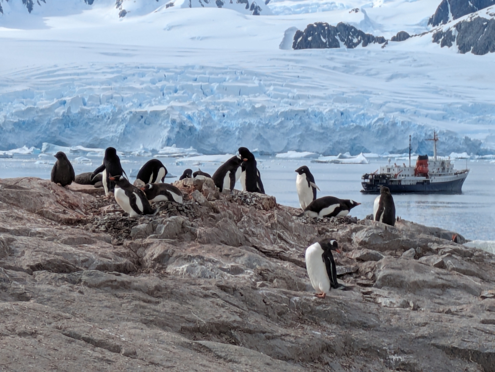
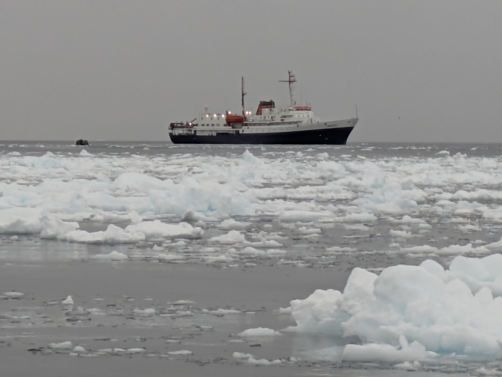
Gentoo and Adelie penguins in front of the MV Ushuaia
In 2015, I discovered the UK had a post office on the continent that needed staff. After some research, I applied for a job as a Port Lockroy assistant to work in Antarctica for five months during the 2016-2017 season. I don’t know what I was thinking. The logistics would be quite difficult for us and only four candidates would make the cut. Needless to say, I didn’t even reach the second round, but my fascination to visit grew.
At some point (December 2019), my blogging friends Steven and Annie Berger posted about their journey to Antarctica (here, here, here, here, and here) and my heart jumped. They inspired me to keep the desire alive. I recently discovered they were actually on the same ship (Ushuaia) than me!
Returning to our ship, MV Ushuaia, through ice floes
And then, in November 2022, the three of us arrived in South America with the goal of driving all the way to “the end of the world,” namely Ushuaia, which is the gateway to Antarctica. I’d never come this close to the seventh continent and I would never be able to visit for less money than from there. Overlanding friends had enjoyed a cruise to Antarctica in the 2023-2024 season for the last-minute price of $5,000 or less, depending on the comfort level of the ship. I could swallow that; I had savings. The plan was hatched for austral summer 2024-2025. We only had to find a solution for Maya. Or so we thought.
I had it all figured out: I’d walk to the closest metro station from our wonderful free camping spot in Santiago, ride the line to the bus station, take a two-hour bus trip west to Valparaiso, explore the town during the day, and return home the same way.
Valparaiso in Chile
Valparaiso and Santiago de Chile
Then, our friends Abigail, Richie, and Zoe from Meat Around The World were interested in joining me. Great! Last minute, we realized that if we rented a car for the day, Mark and Maya would be able to come as well, plus this would give everyone more freedom and comfort than a return journey by public transportation.
Part of our group in Valparaiso (Photo courtesy of Richie Gubler)
The reason we didn’t want to take our own campers was the bad reputation Valparaiso has regarding petty crime, car beak-ins, and tire slashings of foreign-plated vehicles. All of us had just installed new tires in Santiago, so now was definitely not a good time to take extra risks. There certainly is a grimy side to this port city.
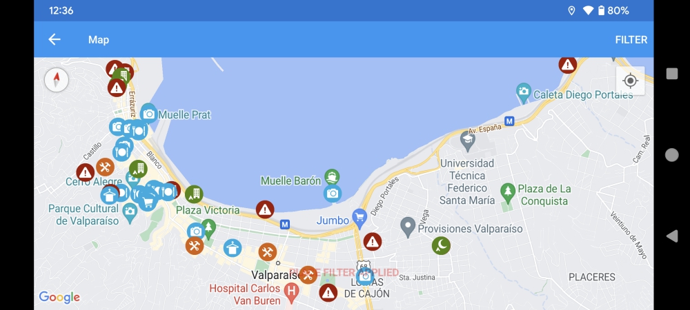
Screenshot of Valparaiso in iOverlander – all the red and white warning signs mark robberies, break-ins, or tire slashings!
After a late start, a two-hour drive on fantastic toll roads, and finding a safe and covered parking spot for the rental car, the six of us set off on foot to discover the colors, murals, and old ascensores (elevators) of Valparaiso during the afternoon. Here is a photo gallery of our day as full-blown tourists.
(As always, hover over or click on photos in galleries to read their captions.)
Pastel-colored row houses
View from Cerro Concepcion
Look over the harbor of Valparaiso
A stately hotel on top of the hill
Colorful alley on Cerro Concepcion
Murals abound in alleys and streets
Girls will be girls – Zoe easily makes friends everywhere she goes.
“The scenery is amazing!” “The people are so friendly here!” “Everything just works!” “Argentina is dirt cheap!” – These were the sentiments shared by fellow overlanding friends when they arrived in Argentina, many months before we did. People loved the change of scenery, culture, attitude, and quality of life, once they crossed that “last” border.
View of a windy mountain road in Northern Argentina
A dusty neighborhood near our camping spot in Maimara
Many old cars litter Cafayate’s streets
Mark and I couldn’t wait to visit. But, sometimes, slow travel bites you in the butt. In March 2024, when the three of us finally arrived in Northern Argentina, prices for everything had doubled, if not tripled or quadrupled, and the excitement of other travelers was lost on us. Because we are on a tight budget? Because we travel with a dog? Because we came from “westernized” Chile with immaculate paved roads, leashed dogs, friendly drivers, clean cities, and modern feel?
Argentinian money comes in many colors and denominations – the biggest one being 2,000 pesos ($2) and the smallest one being 10 pesos (1 cent). The 1,000-peso bill is used the most. There are no coins!
The longest line at an ATM (cash machine) we have ever seen ocured in Tilcara
Line for an ATM in Cafayate
In a nutshell: We had expectations when we crossed the border (and that was our mistake, really; we know better than to have expectations). Yet, what we – initially – found were dusty towns, lots of trash, dangerously grooved roads, ear-piercingly loud motorcycles, the smell of burnt garbage, and loose dogs. There were also a lot of indigenous people, unlike in Chile. Northern Argentina felt like an extension of Peru and Bolivia, and it was NOT cheap.
Maya is sick of the barking, loose dogs and doesn’t want to budge anymore.
Loose dogs on every road in every town of Northern Argentina
Some loose dogs in the park next to our camper in Cafayate
Apart from those experiences as vehicle drivers, long-term travelers, and dog owners, of course there was beauty, joy, and excitement to be found as well. Why else would we still be on the road?
Our destinations in Northern Argentina
Susques
After a beautiful drive, a smooth and efficient border crossing in Pasa Jama, and a disappointing money exchange (our crisp U$100 bills weren’t as crisp as we thought, and the blue dollar “tourist” rate had dropped a lot), we spent our first night near the town of Susques, which has a cute adobe church.
Welcome to Argentina!
The one administrative building that houses all the stops and officials for a border crossing into Argentina
Ready with all the paperwork
Here, we had to choose between the famously pretty but bumpy Ruta 40 South or the paved comfort of Ruta 68. We picked the easy solution and are happy we did as it delivered beauty in the form of scenery and new friends.
Cute adobe church of Susques
The unique interior of the adobe church.
The famous Ruta 40 starts in Susques, next to the restaurant we spent our first night at.
Salinas Grandes
Before reaching our first real tourist town, we stopped at the salt flats of Salinas Grandes. We’d hoped to visit the Ojos, clear pools in the middle of the Salar, on a short van tour, but because of recent rains, this part was too wet to drive on. So, the three of us just walked around the salty terrain with its clear-blue canals – and Maya was a mess!
I believe these channels are formed from mining the salt.
One of the clear canals of the salt flats
Taking Maya for a salty walk on Salinas Grandes
One of the mountains is reflected on the wet salt flats
Purmamarca
In Purmamarca, we only anticipated a hike among the colored mountains. It was a hot afternoon, but the fee for the trail was low and the surroundings bright and attractive. When returning via the center of town, we liked it so much that we decided to spend the night on the sloped parking lot we had pulled into earlier. The pleasant atmosphere of downtown – and the prospect of dinner at a pizza restaurant that didn’t open until 8 pm – had us change plans.
Purmamarca is famous for its colored mountains
Colorful hills surround the trail in Purmamarca
Hiking under a hot sun in Purmamarca
Colorful and hot walk with Maya
Splurging on an excellent pizza and tasty bottle of wine at a local restaurant
Salar de Uyuni – or Salar de Tunupa (the local Quechua people prefer to call the area by its original name) – is located 20 minutes north of Uyuni and is the largest salt flat in the world. It measures 12,000 km2, which, to put it in perspective, is a bit over 1/3 the size of Belgium and four times the surface of Luxembourg. For Americans, Rhode Island fits three times into this Salar and Delaware twice – and New Jersey is twice as big.
(As always, click on or hover over photos in galleries to read their captions.)
Salt, salt, and salt
Mark and “our” Land Cruiser on the Salar
Cool textures
Salt, as far as you can see
Many overlanders prefer to drive and camp on this white, vast surface, usually stopping when they can’t see anything but salt around them. A trip on the salt flat with your own vehicle offers a lot of freedom, solitude, and fun, but it also requires protecting the undercarriage from all that destructive salt and giving it a detailed and thorough cleaning in the end. In the dry season. Once the wet season has started in Bolivia, taking your own home on wheels is a bad idea, because the (wet) salt will get anywhere and destroy everything it touches, over time. Plus, some parts of this area are closed when (too) wet.
Reflection pool on the salt flat
With that in mind, Mark, Maya, and I booked a tour for the day. Even better, we arranged a private excursion for our little family to give Maya (who was recovering from a nasty dog bite) enough comfort and space, and to allow us the privacy and freedom of a trip tailored to just the three of us. We could tell our guide wherever we wanted to go on the Salar, what to skip or limit, and whenever we wanted to move on. And, to be honest, at twice the price of a group tour ($120 for the three of us instead of $60), we believed it was worth the splurge. ????
Eusevio eating coca leaves to stay alert
Prepping for lunch
Maya had a lot of space during the drives
Driving on the salt flat
Our tour started at 10:30am, would finish after sunset, around 8pm, and included lunch and drinks. We decided to skip stop one (the Train Cemetery where we had been living, exploring, and photographing for four days already) and made stop two (salt processing tour and artisanal markets) shorter, for an earlier start on the Salar. A massive rain storm was threatening, so I wanted to stay ahead of that!
Salt block from the Salar
Packaging the salt for consumers
Once on the salt flat, the fun could begin! We stopped by the Ojos de Agua, which our Spanish-speaking guide, Eusevio, called the “breath” of the Salar. Water bubbled up from below, as if something was breathing under the surface.
Bubbles in the Salar
Ojos de Agua
He encouraged us to employ a local guy to take “forced perspective” photos of us and Maya. Since that was affordable, we obliged.
After my cousin and her husband left Cusco on December 6th, Mark and I finished some work assignments and camper projects (and I created a 2024 calendar for my family), and socialized with our Canadian friends Sheri and Jeff. Just as we were ready to leave town, we learned our American motorcycle friends Katherine and Brandon would arrive the following day!
(As always, click on or hover over photos to read their captions.)
Great group photo of us and our vehicles in Cusco
Dinner out with Katherine and Brandon at our favorite vegetarian restaurant in Cusco
Mark gives our friends tips about how to reach Machu Picchu
We didn’t want to miss that, of course, and decided to camp on the edge of Cusco for a couple of nights to spend time with them – and work. We have met up with Katherine and Brandon in “every” country of South America so far: Colombia, Ecuador, and Peru. (And, most recently, Bolivia.) After seeing them several times in Baja, Mexico and Idaho and Oregon in the US.
Drinks and popcorn in Bella with Katherine and Brandon
Katherine carries dog food for strays on her motorcycle – Maya knows!
Waving our motorcycle friends off again – not for long, this time…
Sheri and Jeff – who we were supposed to meet down the road – had finished their Sacred Valley explorations by then and joined us as well. We had fun times together, especially when Jeff revealed one of his T-shirts… I mentioned in a previous post that our friends had a few surprises for us. ????
Back at Piss Alley, where we camped near Jeff and Sheri’s camper for our last nights in Cusco
Drinks out in Cusco with friends – Jeff and Sheri surprised us with this funny T-shirt!
A slightly better look at the surprise T-shirt Jeff was wearing
Tinajani Canyon
Us, truck camper overlanders, moved on and drove for two long days. Our first stop – after filling up with propane at the other end of Cusco – was Tinajani Canyon, where we had camped and walked before.
Crazy drivers in Peru – they always have to cut you off. Always.
Another, long-term, road closure in Cusco
Company of a skinny stray dog while patiently waiting for our propane tank to get filled.
Getting our propane tank topped up on the edge of Cusco
Road work – at every bridge – between Cusco and the border
Arriving in Tinajani Canyon for the second time
It was quiet at night, but a tad chilly at 13,000ft (around 4,000m). We paid the cheese factory a visit, but they were out of Gouda. This is where the exhaustion and sickness caught up with me, leading to an extra night of staying put, for me to rest. The symptoms reminded me of the flu and I was “out” for five days.
Camped in Tinajani Canyon with Jeff and Sheri (Photo courtesy of Sheri Ouellet)
My favorite spot to hang out – protected from the strong winds and enjoying the nice view
Can you spot Thirsty Bella?
Maya keeps me company, but has an eye on the camper (which contains Mark) at all times!
One more visit to the local Tinajani cheese factory
After our crazy, stressful, and unexpected three-day “border run” to Bolivia, hoping to receive sixty extra days as a tourist in Peru (and eventually succeeding), Mark and I needed a quiet place to recover. Our next destination was Arequipa, but we were not in a rush.
Southern Peru
Visited Sites Southern Peru
First, we drove the three hours from the Kasani border to Puno, where we stocked up on groceries. Then, we continued for another two hours to a peaceful, remote lake, Laguna Sara Cocha, to rest and catch up on internet chores. Because the elevation was still quite high, at 13,800ft (4,200m), the nights were cold, so we couldn’t linger too long.
Welcome to Puno
Driving by Puno and its Lake Titicaca
Laguna Sara Cocha
Laguna Sara Cocha
When our trio arrived at the lake, we were happy to find a pretty, free camping spot, surrounded by alpacas and llamas. Perfect!
Camped for a couple of nights by Laguna Sara Cocha
Greeted by alpacas
This is llama and alpaca territory
Curious llamas and alpacas
Flamingos live at high elevations as well!
Imagine our surprise, when at 6am the next morning, a Sunday, we woke up to the sound of hundreds of cars driving by. If we wouldn’t know any better, we’d think we were parked next to a gravel highway! We were baffled by the commotion and brainstormed reasons as to why traffic had picked up so much. Did the inhabitants of the little hamlet nearby all go to church – in their own cars – in Puno? Nope. The cars were driving in the opposite direction, towards no-man’s land. A massive party in the middle of nowhere?
When vehicles surrounded Thirsty Bella and people got comfortable on blankets and in chairs near us, I inquired. Apparently, the annual car rally around the lake took place that day and spectators drove in early to pick good “podium seats”! Unbelievable. Our peace and rest would have to wait until the following day.
Camped close to the action
A car race in session
We embraced this unusual event and reveled in the families having fun on a Sunday morning and afternoon. By the end of the day, only garbage remained.
After we departed the Sacred Valley and Cusco, we had less than two weeks left in Peru, so we headed towards the border with Bolivia, slowly. The idea was to obtain another 60 days or more to meet up with family from Belgium and friends from Canada back in Cusco, the end of November.
Laguna de Huacarpay
Our first night heading east was spent along a small and peaceful lake, enjoyed by local families that Sunday afternoon. The night was relatively quiet, until we were awakened by knocks on the side of the camper at 5am. It was a Peruvian man asking us if anyone else had been camped here in a tent last night. Not that we knew, but why was that important enough to wake up two gringos? We will never know.
A popular campsite for dogs during the weekend
Laguna Huacarpay
Pallcoyo Colored Mountains
Then, we headed to what would become our favorite destination in this country to date. It was a tough one to get to. From the moment we turned off the main road and onto the one-lane side track, we had to back up for three tour vans. We figured in the afternoon, it would be quieter; hence our late start… These were tourists heading back to Cusco at 3pm, after two hours of driving down the mountain.
Luckily, we didn’t encounter anyone else on our way up this narrow, tricky road. After an hour of exercising steel nerves and concentration, we pulled over along the river. Our only company some locals passing by on motorcycles or cars, but mostly a shepherd and her flock of sheep, llamas, and alpacas.
Narrow road driving up the mountain
Camped among sheep, llamas, and alpacas
Curious llama
Our riverside camping spot for a few nights
Maya loves splashing in the water
The mountain river next to our campsite
The following day had one purpose: watch the traffic patterns on this tight, gravel road (to use that information for our drive to the top – and back down) and figure out if we would take the camper up or just the truck (leaving our home behind for half a day again). Or, to hitch a ride or pay our way with a tour van, which would mean less flexibility and a bigger crowd.
After deciding to take our entire truck camper up, we left at 6:30am to arrive at Pallcoyo Mountain, also called Three Colored Mountains or Three Rainbow Mountains, an hour later. I was impressed by the scenery along the way. It was as if we were driving through a nature documentary in the Andes Mountains (we were!) – stunning terraces, bucolic scenes like a kid tending to a donkey and a Quechua woman carrying a lamb in a bag on her back that jumped out as we passed, and spectacular yet barren mountain sides at this high elevation.
Leaving with the first light
Making our way up the mountain, along terraced fields
Roaming About – Liesbet Collaert & Mark Kilty & Maya
We have been perpetual nomads as RVers, sailors, house and pet sitters, and overlanders since 2003. Currently, the three of us are roaming about Western Europe, searching for our next camper.
As lifetime adventurers, we are self-employed and maintain a tight budget. This blog is about all that – and more – to inspire a life less ordinary. Don’t dream but do! 🙂
This Daily Travelogue is a labor of love for our families and friends at home and around the world. Prior to 2020, all our trips were documented on yearly blogs which can be accessed below. THIS WORDPRESS BLOG IS A COPY OF OUR MAIN BLOG WHICH ALSO CAN BE ACCESSED BELOW. Be safe, stay healthy, and stay connected.